 Arctic sea ice: Patrick Kelley | USGS
This week the extent of Arctic sea ice dipped below the extent for 2007, according to the National Snow and Ice Data Center (NSIDC). As you may remember, the 2007 season holds the record for lowest Arctic sea-ice extent in recorded history.
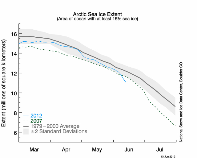 National Snow and Ice Data Center
Walt Meier at NSIDC tells me the melt is accelerating, notably in the Bering Sea, where higher than normal winter ice hung around two to four weeks longer than average. But it’s thawing fast now.
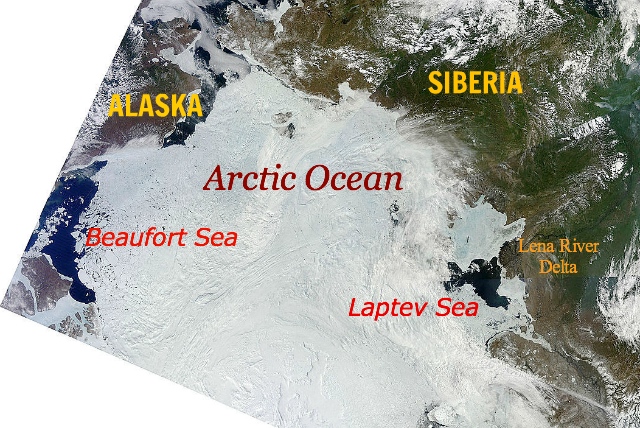 Arctic Ocean, 14 June 2012, sea ice opening at Beaufort and Laptev seas: NASA
The Beaufort Sea north of Alaska and Canada and the Laptev Sea north of Siberia are also melting quickly. “We don’t normally see ice opening so fast in those areas,” says Meier. “This is an indication that the ice there is pretty thin.”
As you can see from the satellite mosaic of the Arctic for today, 14 June (above), the rapidly melting Laptev Sea lies at the downstream end of the mighty Lena River in Siberia. The Beaufort Sea lies at the downstream end of Canada’s mightiest river, the MacKenzie River (delta not visible)—where May temperatures rose well above the 20th-century average (see last image, below).
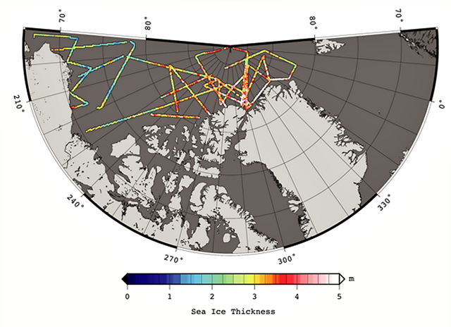 Arctic sea ice thickness derived from the 2012 Operation IceBridge ?between 14 March and 02 April 2012: S. Farrell and N. Kurtz, NASA Goddard Space Flight Center.Ice thickness data (above) show the Beaufort’s sea ice to be thin—3 to 6 feet (1 to 2 meters). That’s the signature of first-year ice. Which means it will be prone to melting completely this summer. Sorry, polar bears, bearded seals, ringed seals, and walruses.
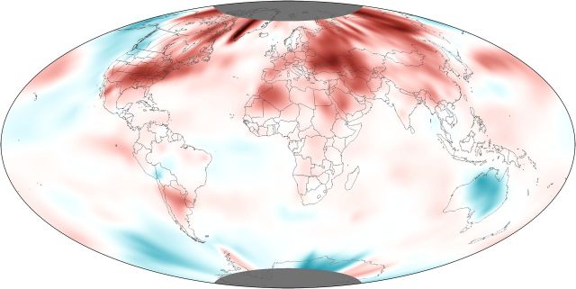 Global temperature anomalies, May 2012: NOAA
Overlay the current sea ice melt map onto this map of May 2012 temperature anomalies. You can see how warm it was in the Beaufort Sea (upper left). The Laptev Sea / Lena River region is not visible in this view.
To put things in a bigger perspective, the global temperature average in May 2012 was the second warmest in history. Records date back to 1880.
May 2012 also marks the 36th consecutive May and the 327th consecutive month—that’s more than 27 years—with a global temperature above the 20th century average, reports NOAA’s Environmental Visualization Laboratory.
